

Did you know that the Thirteen Colones’ borders changed over time? It isn’t like the settlers claimed predefined territories when they came to the New World, instead, they had to enter the wilderness and stake their claims.
Because they were settling land and building civilization from the ground up, the colonists’ original claims were small, but as the population grew, the colonies expanded. The shape and size of each colony was influenced by the terrain, charters, and adjacent colonies.
Throughout the 17th and 18th centuries, the Thirteen Colonies often found themselves in the midst of land disputes with other colonies — many of these land disputes had to be settled by Congress after 1776.
I’ve often wondered how each state would have looked if it had maintained the greatest extent of its claims, rather than compromising to settle a land dispute. Obviously, this would have altered the overall shapes, sizes, locations, names, and even quantity of the other states, but just for once, let’s look at each of the thirteen original states using the largest area each state has ever claimed.
Connecticut
Connecticut used to claim some land that is now northern Pennsylvania and Ohio. Congress ended Connecticut’s claim to northern Pennsylvania in 1782, but Connecticut held onto a portion of land along Lake Erie — known as the Western Reserve — until Connecticut ceded the land to the federal government in 1800.
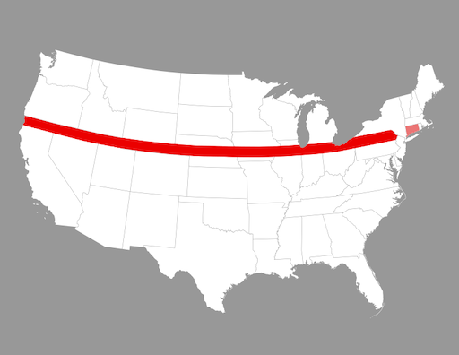
According to the Connecticut Charter of 1662, Connecticut’s boundaries were defined as extending all the way to the “South Sea,” which is the Pacific Ocean. If this swath of land had been maintained by Connecticut, the state would have been about 70 miles tall and 2,700 miles wide and would have contained the cities of Erie, Detroit, Cleveland, Chicago, Des Moines, Omaha, Cheyenne, and Salt Lake City!
Delaware
Delaware did not have land claims that were larger than its modern borders, however, the state was formerly considered part of Pennsylvania and called the Lower Counties on Delaware, until Delaware separated from Pennsylvania in 1776.
Georgia
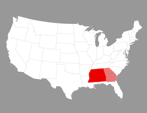
The state of Georgia had claimed land extending westward to the Mississippi River since its colonial days, but Georgia didn’t possess its largest claims until Great Britain ceded some land just north of the Spanish colony of West Florida to Georgia in 1784. Georgia ceded the majority of its western land to the federal government in 1802, leaving the state with the borders it currently has.
Maryland
The only major change to Maryland’s borders occurred in 1791, when Maryland ceded approximately 69 square miles of land to form the District of Columbia.
Massachusetts Bay
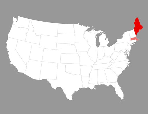
When the United States declared its independence, the state of Massachusetts Bay possessed much more land to the north — most of which is now the state of Maine. From the 1780s to the 1820s, the state lost its northern land, part of its name, and (technically) its statehood — the large state of Massachusetts Bay became the small commonwealth of Massachusetts.
New Hampshire
New Hampshire’s current boundaries are the largest boundaries that the state has had.
New Jersey
Besides New Jersey’s previous minor overlap with New York and the time that the colony was divided into East Jersey and West Jersey, the state of New Jersey has not had major border changes.
New York
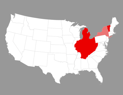
Not only did New York own the Erie Triangle and the land that is now Vermont, but the state also had weak claims to a large portion of western land that is now part of the states of Michigan, Ohio, Indiana, Illinois, Kentucky, West Virginia, Virginia, Tennessee, and Alabama.
North Carolina

Like many of the thirteen original states, North Carolina claimed land that extended to the Mississippi River, however, North Carolina ceded its western half in 1790, and this western portion is now mostly the state of Tennessee.
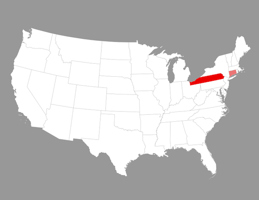
Pennsylvania
The only major change to Pennsylvania’s boundaries occurred in 1792 when the state purchased the Erie Triangle from the federal government.
Rhode Island
No major changes to the borders of the state of Rhode Island and Providence Plantations have occurred.
South Carolina
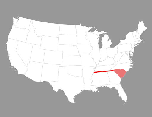
South Carolina also had western claims terminating at the Mississippi River, though this land technically belonged to Georgia and South Carolina’s claims were apparently based on faulty knowledge of the area’s geography.
Virginia
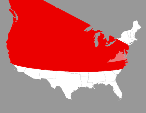
According to the 1609 Virginia Grant, Virginia’s southern boundary was set along a parallel near modern-day South Carolina all the way to the Pacific Ocean and its northern boundary was set from near Long Island northeastward to the Pacific Ocean. This places most of the current United States, including part of Alaska, within the borders of Virginia.
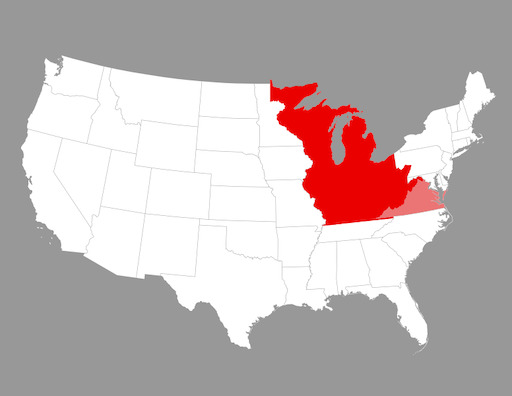
Virginia’s boundaries were greatly reduced soon after, but during the year 1776, Virginia still controlled most of the land around the Great Lakes. Virginia ceded its claim to Pennsylvania in 1779, its claim to the Northwest Territory in 1784, its claim to Kentucky in 1792, and its claim to West Virginia in 1863.
Which state’s historical borders do you think are the best and why?
Onward American 🇺🇸
Source: Territorial Evolution of the United States
