

The northeastern region of the state of Vermont is sometimes called the Northeast Kingdom. This nickname is attributed to the former Vermont Governor George Aiken, who first used it in a 1949 speech.
I was recently exploring state borders on a map, as one does, when I came across something peculiar: the most northeastern corner of the Northeast Kingdom looked especially odd. You know what this means, we must add a new Odd Corner to the series.
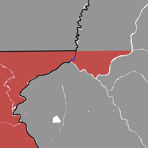
Because the description of this Odd Corner, the Northeastern Corner of Vermont, is particularly verbose and all of my research failed to provided me with its common nickname, I am bestowing the honorary nickname of Northeast Nook on the corner.
The Northeast Nook

I have always simplified Vermont’s shape to a V in my mind, however, this corner of Vermont that juts into New Hampshire throws a wrench into my simplification. I mean, why would they make Vermont’s eastern border an intuitive, diagonal line when they could make it a chaotically winding line? Why should they make a state look like its initial when it is already incredibly close?
Though it may seem like they missed a great opportunity, the decision to place Vermont’s eastern border on the Connecticut River is quite logical, especially when looking at the border from the ground, since you can physically see a river and not an intangible, NNE-SSW line.
Sadly, I was unable to find anything that discussed the reason for the existence of this corner, yet this may be the case due to its relative simplicity; it is likely that this oddity merely exists because Vermont’s eastern border follows the Connecticut River from the Parallel 42º44’N to the Parallel 45ºN. The Connecticut River just happens to strangely squiggle less than a mile south of the 45th Parallel, consequently shaping the northeastern corner of Vermont in the same, squiggly fashion.
Technically, this border was established before the days of Vermont; this segment of the Connecticut River used to be the New York Colony-New Hampshire Colony border until the northeastern region of New York Colony declared itself independent and later became the state of Vermont. I have a post that describes Vermont’s separation from New York in greater detail.
Well, it seems the Northeast Nook is the result of a rational placement of the border, however, from one perspective, it might have made sense to continue New Hampshire’s border down Halls Stream until it met the Connecticut River, rather than terminating on the 45th Parallel; this would have produced a more rounded corner for Vermont, though the state would lose an entire square mile of land.
I would not actually recommend making that change to the border, especially since it would drastically alter the lives of the Vermonters who live east of Halls Stream. This conceptual border adjustment would have needed to be carried out during the formation of the states, which was during the colonial era in America.
Fun fact: you only need to drive a half mile to go from the US-Canada border, through Vermont, and into New Hampshire. This half mile trip will even take you through the entire community of Beecher Falls, Vermont.
Have you ever visited northeastern Vermont?
