

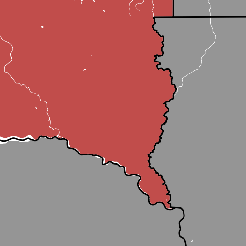
Have you ever noticed South Dakota’s uniquely shaped eastern border like I have? South Dakota has a pronounced indent in its northeastern corner, and a jutting spike in its southeastern corner, which one might call an odd corner.
What is South Dakota’s southeastern corner called?
After many online inquiries and much digging through the internet, I found nothing referring to the southeastern corner of South Dakota as anything other than that verbose description, unlike most other states, which have already given their odd corner an eccentric nickname. Therefore, I will be taking liberty to call this corner the “Southeast Spike”; why not?
My numerous attempts to uncover any information about this South Dakotan corner were fruitless; nothing acknowledged the peculiar shape of this spike, let alone the history of it. Just about the only interesting fact the internet provided was that this odd corner is almost entirely contained in Union County, SD. It seems as if the Southeast Spike is scarcely recognized and hardly written about.
Fear not, South Dakota, I have not neglected your odd corner!
How did South Dakota get its southeastern corner?
Again, I was incapable of finding any answers to this question, but I will not leave you empty handed, I will explain my theory!
I can only assume that this southeastern spike exists simply because the territory of Dakota was organized from the unorganized territory left over from Minnesota’s admission into the Union and the northern land of Nebraska Territory. The Nebraska Territory-Dakota Territory border was set along the parallel 43ºN until it met up with the Missouri River, where it then followed the river.
Dakota Territory was later split roughly along the parallel 45º56’N into two halves, which were admitted as the states of North and South Dakota; South Dakota occupied the southern portion, hence the name. A consequence of Iowa’s and Nebraska’s already being established as states, South Dakota had no other option but to allow its southeastern border with Iowa and Nebraska to exist along the Big Sioux River and Missouri River, respectively.
In my opinion, that is likely why South Dakota’s southeastern corner is shaped the way it is, that’s also why it earned a seat in this series!
Note: if you would ever like to look up the parallels or borders mentioned in my posts, the internet may be able to show you images of borders or parallels and meridians. Otherwise, map websites or apps should allow you to search for a point using coordinates, as long as you specify a latitude and a longitude, i.e., use 42º59’55”N, 100º11’54”W, or 43.9985ºN, 100.1984ºW, for the approximate South Dakota-Nebraska border.
Fun fact: Dakota Dunes appears to be the southeastern most town, technically an unincorporated community, in South Dakota, far into the Southeast Spike. Dakota Dunes is also one of the best places to live in South Dakota, at least, niche.com claims so.

What do you think about the Southeast Spike?
