

Missouri is the Show-Me State, but sinkholes are not uncommon in this state, and Missouri is also home to some of the largest earthquakes in US history. It could be argued that Missouri is more correctly referred to as the “Shake-Me State.”
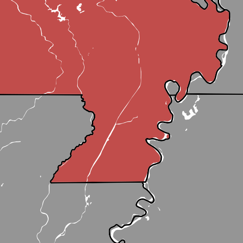
Seriously, what is the deal with Missouri’s “bootheel?” The sources I’ve linked use bootheel, but for clarity, I will use boot-heel. Missouri’s northern border is a straight line, and so is its southern border, besides that little nub! It’s almost as if Missouri has one, singular little tooth jutting into Arkansas. That’s right, we are talking about your odd corner, Missouri!
Missouri’s boot-heel was just about the only portion of the state below the 36º30’N parallel, which was the specified border between free and slave states from the Louisiana Territory by the Missouri Compromise, therefore Missouri should have been a free state. However, the compromise allowed one exception: Missouri, though being mostly above the parallel, would be a slave state, although, Missouri was one of the four slave states that did not secede from the Union during the Civl War.
The need to consider the balance of free and slave states added an extra level of complexity to the development of states and territories, much more than I previously assumed. Now I am done with this tangent, back to the point.
How did Missouri acquire its boot-heel?
Missouri, a moderately central state, owns an extension of land beyond the majority of its southern border, known as the boot-heel, apparently due to its resemblance to the heel of a boot.
You might also have noticed that Missouri’s odd corner is adjacent to Kentucky’s odd corner from a previous post, the Kentucky Bend! In fact, the Missouri Bootheel is on the opposite side of the Mississippi River from the Kentucky Bend!
The boot-heel actually used to be a part of the territory of Missouri when Louisiana Territory was renamed “Missouri Territory” to eliminate confusion since Louisiana Territory was separate from the already admitted state of Louisiana. Seven years later, a new territory formed from the southern land of Missouri Territory called Arkansaw Territory, and yes, that’s how its name was spelled until “Arkansas” became more prevalent.
The Arkansaw Territory-Missouri Territory border roughly ran along the very same 36º30’N parallel, which placed the future boot-heel on the Arkansas side of the border. This odd corner would likely never have existed if it wasn’t for one man who lobbied for his land to be included into Missouri; John Hardeman Walker.
Early in the 19th century, Walker moved to the area near New Madrid, which is in southeastern Missouri today, and only a year after his arrival, the New Madrid earthquakes began. These earthquakes’ magnitudes were in the range of 7.0 to 8.6, and the damage they caused was extensive; lives were lost, properties were destroyed, and landscapes were altered. The earthquakes were felt as far away as Canada, no less than 650 miles away!
Many in the New Madrid area moved away during the earthquakes, as any reasonable person would, but not Walker, instead, he obtained more land! After Walker’s lobbying, it was eventually decided that the territory, and then the state, of Missouri would include Walker’s land, creating the boot-heel of Missouri.
Fun fact: Walker became the first sheriff of New Madrid County, MO! I guess if New Madrid’s earthquakes could not kill Walker, then, likely, neither could their criminals! Seemingly, this man could not be killed, until, sadly, he succumbed to Cholera.
What do you think about Missouri’s boot-heel?
